2013 Western U.S. Expedition
Traveling
the Wide-Open
West in Style
20130514
- 20130707
Final update: 20130709 from San Diego, CABack to Bill Caid's Home Page.
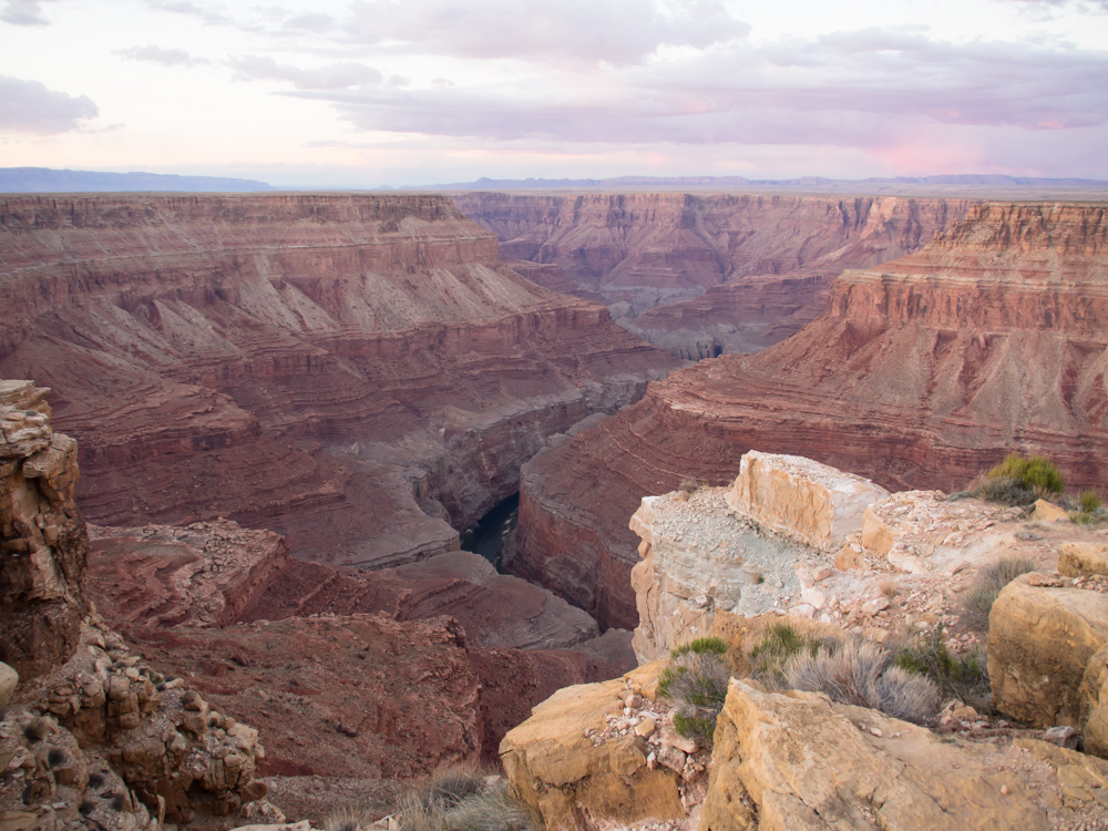
Sunset
view of Marble
Canyon from
the north side
of
the Colorado
River from our
remote campsite
at
Horseshoe
point.
The Trip
The first use of the rig was some small outings in San Diego county, a trip to the Overland Expo and a week in Baja in 2011. The Baja Expedition is detailed on Baja Trip 2011 and demonstrated that the concept was viable and that the platform was sufficiently stable to execute a long trip To be sure, the Baja trip showed that there was some effort required to address some issues, a front bash plate protecting the radiator in particular, but most of the items were nits.
Since then, we have completed several extended trips in Thor including an extended western US trip in 2011 and a full cross-country trip in 2012 that took us through the south and as far north as Niagara Falls, NY.
The western U.S. is one of our favorite areas, Mexico notwithstanding. It is sad that the political situation in Mexico prevents widespread travels without the constant, nagging fear of being kidnapped or killed by the narcos. But, since Mexico is not a candidate, both due to actual climate and political climate, we settled for the west. Our planned route will first take us to the Tucson, AZ area and then north to Flagstaff, AZ for the Overland Expo. At OvX we will hook up with some U500 expedition camper guys and do some exploring in the Grand Staircase area of southern Utah. Since the U500 guys have "day jobs", that portion of the trip will only be about a week. Once they return to civilization, we will be on our own and will likely continue north. It will be hot when we depart, over 100 degrees in the desert and sadly our air conditioning unit that we added to the cab is on the fritz. But, no matter, we will persevere.
Tracking Our Location Via The SPOT
Some years ago, after a scary mechanical failure in the canyons and mesas of southern Utah, we decided that we need a better way to advertise our position and call for assistance if needed. Kathleen found out about the SPOT which is a GPS locator that transmits your coordinates via satellite so that others can see your location. The location is plotted on Google maps and a "bread crumb" feature is available for an additional fee. We have the enhanced service, so you can see our historical path back 50 updates or so. See our current location plotted on Google Maps in Real-Time via SPOT satellite geo-locator device. This page is "book-markable" and is updated approximately every 15 minutes, but may miss updates due to inability of our transmitter to reach the satellite. The communication is "open loop" so the device never knows if it's messages are actually going anywhere, it just keeps trying until the next update is available. If we are in a congested urban area with high buildings (like Manhattan) or in deep canyons, the position may not update. We try to send an "OK" message once a day just to let everyone know that we are, in fact, OK.Connecting and Contacting Us While on the Trip
Because of internet connectivity issues on a previous trip, we purchased a MiFi cell phone modem that allows us to connect nearly anywhere there is 3G service via cell phone (which is most of the cell phone service area available today). But, as we all know, cell phones are useful many places, but not everywhere has coverage, particularly in the remote areas of the western U.S. Our phones and the modem are enabled daily so you may contact us, although it may take a few days for us to respond. But, we will respond. If you are close to our current position or planned path and would like to meet, just give us an email or call and we will do what we can to hook up. If you are on the moglist (tx4x4.com) or BenzWorld, my cell number is available there. My email, spelled out, is "bcaid at yahoo dot com".Trip Details
The
link table
below contains
links to the
photos and
dialog
for each of
the days of
the
expedition.
This table
will be
updated as the
trip
progresses.
Back to Bill Caid's Home Page.
Copyright Bill Caid 2013